01 Load GAMMA results
Pipeline: examples/01_load.toml. Tutorial: nbs/Tutorials/CLI/CampiFlegrei/01_load.ipynb.
Input
A GAMMA processing directory with co-registered SLCs and geocoding products:
gamma/
├── rslc/       YYYYMMDD.rslc, YYYYMMDD.rslc.par   (co-registered SLCs, one per date)
├── geocoding/  <geo>.hgt, <geo>.diff_par, <geo>.lt_fine, <geo>.lv_theta, <geo>.lv_phi
└── DEM/        dem_seg_par
Ask the user for the directory, the reference date (reference, the date the rslc stack is flattened to)
and the date prefix of the geocoding files (geo) if they are not obvious from the file names. The defaults
of the file are the ones of the sample data set, Campi Flegrei (data/CampiFlegrei/gamma, decision 0033).
moraine run examples/01_load.toml --workdir WORK --var gamma=/path/to/gamma --var reference=20200707 --var geo=20200707
GAMMA must be on PATH (which base_calc phase_sim_orb geocode create_offset).
Steps and outputs (WORK/raw/)
| step | command | output |
|---|---|---|
| rslc | load-gamma-flatten-rslc | rslc.zarr (nlines, width, nimages) complex64, flat earth and topography removed |
| lat_lon_hgt | load-gamma-lat-lon-hgt | lat.zarr, lon.zarr float64, hgt.zarr float32, (nlines, width); nan where 0 in GAMMA |
| look_vector | load-gamma-look-vector | theta.zarr, phi.zarr (elevation / orientation angle) |
| range | load-gamma-range | range.zarr slant range distance |
| metadata | load-gamma-metadata | meta.toml (dates, wavelength, heading, pixel spacing, perpendicular baselines) |
| web_mercator | transform | e.zarr, n.zarr web mercator coordinates (EPSG:3857) for map plots |
| rslc_pyramid | ras-pyramid | rslc_pyramid/ to check the interferograms, decimated: SLC pixels cannot be averaged (their scatterer phases differ), so the whole scene is speckle; zoom in, or look at the mean pyramid of the n2f interferograms of 02 |
Sample data (Campi Flegrei, 981 x 4160 x 92, 2026-10-08): 162 s, 126 s of it phase_sim_orb for each date
(64 threads); the pyramid takes 21 s.
Expected results (sample data)
| result | sample value | sane range |
|---|---|---|
rslc.zarr |
complex64 (981, 4160, 92), chunks (1000, 1000, 1) | the number of dates in rslc/ |
rslc_pyramid amplitude |
p01 0.023, p50 0.29, p99 1.56 | p50 roughly 0.1-1 |
rslc_pyramid nan_fraction |
0.40 (the Gulf of Pozzuoli, zero in the coregistered SLCs) | small, unless water or the footprint is masked |
meta.toml dates |
92, 12 days apart | all dates of rslc/, in order |
Figures
Quicklooks of the sample data run of 2026-10-08:
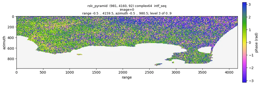
Sequential interferogram 0 of the raw stack (quicklook raw/rslc_pyramid --show intf_seq --index 0): noisy single
look phase with structure on land, nan on the gulf.
Checks
moraine info raw/rslc.zarr: shape (nlines, width, number of dates inrslc/).moraine info raw/rslc_pyramid: amplitude p50 around 0.1-1. A nan_fraction near 1 means the GAMMA files did not match; on the sample data 0.40 is the sea.moraine quicklook raw/rslc_pyramid --show intf_seq --index I -o intf.png: sequential interferograms. Expect noisy phase with visible fringes / structure in coherent areas; pure uniform noise everywhere suggests a wrong reference date or unflattened data.raw/meta.toml:datesmust list all dates in order.
Problems
sh: base_calc: command not found: GAMMA is not on PATH.- A step fails on a missing
*.par/ geocoding file: checkgeo/reference. - The scratch directory (
raw/scratch) keeps GAMMA intermediates; it can be deleted after the run.